MapsGL - Javascript SDK Usage
While the MapsGL SDK can be used on its own in conjunction with a third-party mapping library, you may want to take advantage of the various interface controls and elements currently offered by the AerisWeather Javascript SDK and its InteractiveMapApp component. The InteractiveMapApp component is a fully-functional, feature-rich interactive map application, which can serve as your own weather dashboard or be integrated into your custom weather applications.
Getting Started
Using the MapsGL SDK with the Javascript SDK works similarly to modules in that the AerisWeather contains a mapsgl() method as the entry point for working with MapsGL functionalty.
The mapsgl() entry point will load the MapsGL SDK assets asynchronously and return a Promise once all required assets have loaded and a MapController instance has been set up and integrated with your InteractiveMapApp instance:
// load in MapsGL sdk and set up relevant layer controls
aeris.mapsgl(app, options).then(({ controller, mapsgl }) => {

    // "controller" is the MapController instance created for you
    // "mapsgl" is the MapsGL SDK public interface if you need to access more MapsGL SDK features

});
At a minimum, you will need to provide your InteractiveMapApp instance as the first argument when calling aeris.mapsgl(), which is the app variable in the above example. You may also pass additional options as the second argument which allows you to further integrate your desired MapsGL layers into your map application’s layer control panel.
The following interfaces describe the supported options:
interface MapsGLLayer {
	id: string;
	title: string;
	value: string;
	controls: Record<string, any>;
	options: Record<string, any>;
	index: number;
	segments: Array<MapsGLLayer>;
	buttons: Array<any>;
}

interface MapsGLMapOptions {

    // MapsGL SDK version (uses "latest" by default)
	version: string;

    // layer panel button configurations for MapsGL-related layers
	layers: Array<MapsGLLayer>;
}
The layers option provides the layer control configuration for your MapsGL-related layers which will get injected into your existing InteractiveMapApp instance’s layers control panel. Refer to the Layers Panel documentation from the Javascript SDK for additional information on the supported properties outlined above.
Example Setup
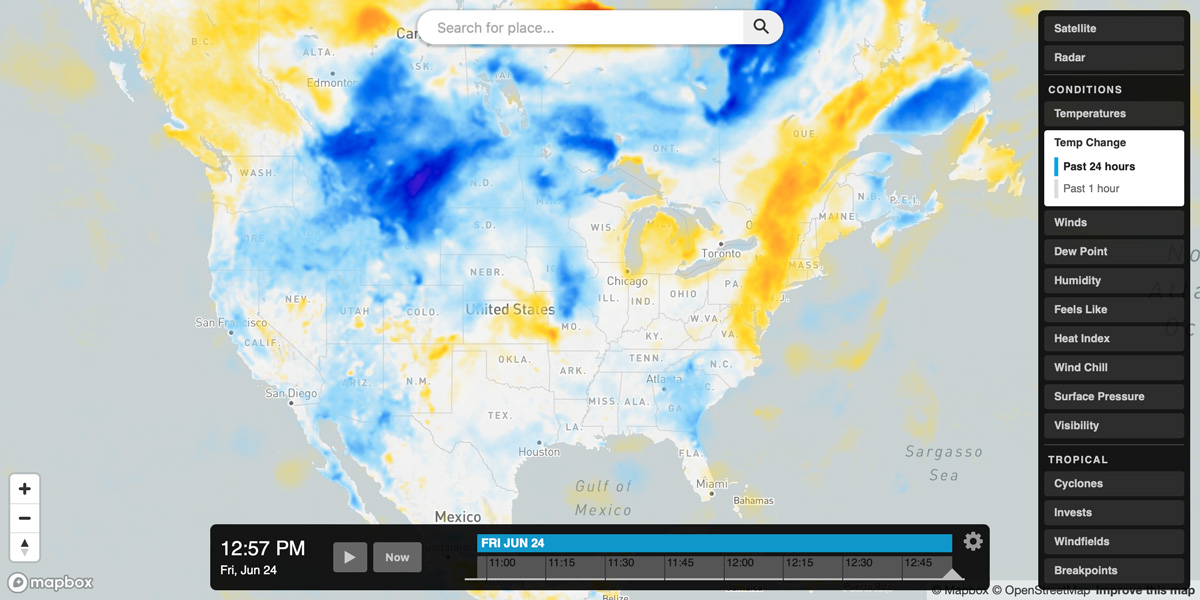
The following example demonstrates how easy it is to integrate the MapsGL SDK and related weather layers into an InteractiveMapApp. Here we’re adding the standard raster satellite layer and Tropical module from the Javascript SDK along with the default radar and conditions-related weather layers built into the MapsGL SDK.
window.addEventListener('load', () => {
    const aeris = new AerisWeather('CLIENT_ID', 'CLIENT_SECRET');

    aeris.apps().then((apps) => {
        const app = new apps.InteractiveMapApp('#map', {
            map: {
                strategy: 'mapbox',
                center: { lat: 40, lon: -90 },
                zoom: 4,
                map: {
                    accessToken: 'MAPBOX_TOKEN'
                }
            },
            panels: {
                layers: {
                    buttons: [{
                        id: 'satellite',
                        value: 'satellite:75',
                        title: 'Satellite'
                    }]
                }
            }
        });

        app.on('ready', () => {

            // load in MapsGL sdk and set up relevant layer controls
            aeris.mapsgl(app, {
                layers: [{
                    title: 'Radar', value: 'radar', options: {
                        animation: {
                            interval: 12
                        }
                    }
                }, {
                    title: 'Conditions',
                    buttons: [
                        { title: 'Temperatures', value: 'temperatures' },
                        { title: 'Temp Change', value: 'temp-change', segments: [
                            { title: 'Past 24 hours', value: 'temperatures-24hr-change' },
                            { title: 'Past 1 hour', value: 'temperatures-1hr-change' },
                        ] },
                        { title: 'Winds', value: 'winds', segments: [
                            { title: 'Particles', value: 'wind-particles' },
                            { title: 'Fill', value: 'wind-speeds' },
                            { title: 'Arrows', value: 'wind-dir' },
                            { title: 'Barbs', value: 'wind-barbs' }
                        ] },
                        { title: 'Dew Point', value: 'dew-points' },
                        { title: 'Humidity', value: 'humidity' },
                        { title: 'Feels Like', value: 'feels-like' },
                        { title: 'Heat Index', value: 'heat-index' },
                        { title: 'Wind Chill', value: 'wind-chill' },
                        { title: 'Surface Pressure', value: 'pressure', segments: [
                            { title: 'Fill', value: 'pressure-msl' },
                            { title: 'Contours', value: 'pressure-msl-contour' },
                        ] },
                        { title: 'Visibility', value: 'visibility' },
                    ]
                }]
            }).then(({ controller, mapsgl }) => {

                // add the MapsGL legend control
                controller.addLegendControl(app.$el, { width: 300 });

                // add the MapsGL data inspector control
                controller.addDataInspectorControl();

                // add Tropical module from the Javascript SDK
                aeris.modules().then((modules) => {
                    app.modules.add(modules.groups.Tropical);
                });

            });
        });
    });
});