MapsGL Android - Adding custom GeoJSON data
This example renders a static GeoJSON object consisting of a polygon feature to the map. Two separate style layers are associated with the data source: one that fills the geometry and another that draws a thicker outline along the geometry edges.
It is the Android port of the MapsGL JS Adding custom GeoJSON data example and renders the same Portugal polygon. The complete activity ships in the MapsGL Android SDK demo as AddGeoJsonLayerActivity, reachable from the demo’s Docs Examples menu.
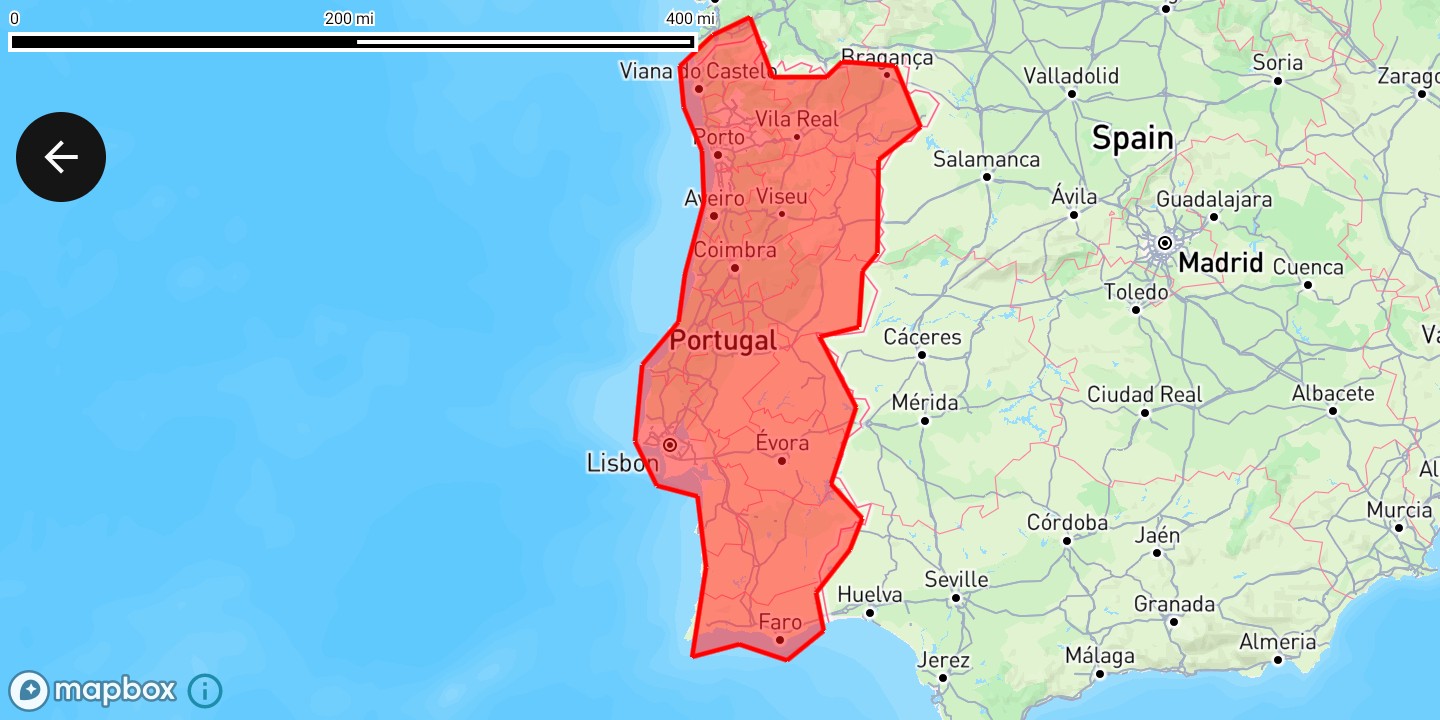
Set up the map
Create a MapboxMapController for the MapView, position the camera, and wait for the map to finish loading before adding sources and layers.
import com.mapbox.maps.MapboxMap
import com.xweather.mapsgl.config.weather.account.XweatherAccount
import com.xweather.mapsgl.map.mapbox.MapboxMapController
import com.xweather.mapsgl.types.Coordinate

val xweatherAccount = XweatherAccount(
    getString(R.string.xweather_client_id),
    getString(R.string.xweather_client_secret),
)

val controller = MapboxMapController(mapView, xweatherAccount)
val mapboxMap = controller.mapboxMap ?: return

// Matches the JS example's `center: [-8, 40], zoom: 5`.
controller.setCenter(Coordinate(40.0, -8.0))
controller.setZoom(5.0)

val mapLoadedCancelable = mapboxMap.subscribeMapLoaded {
    // Add the source and layers here — see below.
}
subscribeMapLoaded is the Android equivalent of the JS example’s controller.on('load', …) block. Keep the returned Cancelable so it can be cancelled in onDestroy.
Add the GeoJSON source
Assign the features to GeoJSONSourceDescriptor.data and register the descriptor with MapController.addSource. This is the direct equivalent of the JS example’s addSource('country-region', { type: 'geojson', data: … }).
import com.mapbox.geojson.FeatureCollection
import com.xweather.mapsgl.sources.source.spec.GeoJSONSourceDescriptor

// Add a custom polygon as GeoJSON data.
if (!controller.hasSource("country-region")) {
    controller.addSource(
        GeoJSONSourceDescriptor(id = "country-region").apply {
            data = FeatureCollection.fromJson(COUNTRY_REGION_GEOJSON)
        },
    )
}
COUNTRY_REGION_GEOJSON is the same single-polygon FeatureCollection the JS example embeds — see the GeoJSON data below.
You can also add the source first and assign data on the runtime GeoJSONSource afterwards. That is the right choice when the features arrive later than the source does.
import com.xweather.mapsgl.sources.GeoJSONSource

controller.addSource(GeoJSONSourceDescriptor(id = "country-region"))
(controller.getSource("country-region") as? GeoJSONSource)?.data =
    FeatureCollection.fromJson(COUNTRY_REGION_GEOJSON)
See custom data sources for the remote-URL and bundled-asset variants.
Fill the polygon region
Add a FillLayerDescriptor that references the source id. Style values are wrapped in StyleValue.Constant, the Kotlin equivalent of the JS example’s literal paint values.
import androidx.compose.ui.graphics.Color
import com.xweather.mapsgl.layers.spec.FillLayerDescriptor
import com.xweather.mapsgl.style.FillLayerPaint
import com.xweather.mapsgl.style.FillPaint
import com.xweather.mapsgl.style.StyleValue

val regionColor = Color(0xFFFF0000) // `#ff0000`, as in the JS example

// Fill the polygon region.
if (!controller.hasLayer("region-fill")) {
    controller.addLayer(
        FillLayerDescriptor(
            id = "region-fill",
            source = "country-region",
            paint = FillLayerPaint(
                fill = FillPaint(
                    color = StyleValue.Constant(regionColor),
                    opacity = StyleValue.Constant(0.5),
                ),
            ),
        ),
        beforeID = null,
    )
}
Add a thicker outline
Because sources and layers are created and cached separately, the same source id can back a second layer. Add a LineLayerDescriptor for the outline.
import com.xweather.mapsgl.layers.spec.LineLayerDescriptor
import com.xweather.mapsgl.style.LineLayerPaint
import com.xweather.mapsgl.style.StrokePaint

// Add a thicker outline to the region.
if (!controller.hasLayer("region-outline")) {
    controller.addLayer(
        LineLayerDescriptor(
            id = "region-outline",
            source = "country-region",
            paint = LineLayerPaint(
                stroke = StrokePaint(
                    color = StyleValue.Constant(regionColor),
                    thickness = StyleValue.Constant(5.0),
                ),
            ),
        ),
        beforeID = null,
    )
}
Clean up
Unlike a browser page, an Android activity is torn down and recreated across configuration changes. Remove the layers and then the source they reference, and cancel the map-loaded subscription, in onDestroy.
override fun onDestroy() {
    if (controller.hasLayer("region-outline")) controller.removeLayer("region-outline")
    if (controller.hasLayer("region-fill")) controller.removeLayer("region-fill")
    if (controller.hasSource("country-region")) controller.removeSource("country-region")
    mapLoadedCancelable?.cancel()
    mapView.onDestroy()
    super.onDestroy()
}
The GeoJSON data
The polygon is the same FeatureCollection used by the JS example, stored as a raw Kotlin string:
private const val COUNTRY_REGION_GEOJSON = """
{
    "type": "FeatureCollection",
    "features": [
        {
            "type": "Feature",
            "properties": {
                "type": "Sovereign country",
                "name": "Portugal",
                "continent": "Europe",
                "region_un": "Europe",
                "subregion": "Southern Europe",
                "region_wb": "Europe & Central Asia"
            },
            "geometry": {
                "type": "Polygon",
                "coordinates": [
                    [
                        [-9.034817674180246, 41.88057058365967],
                        [-8.67194576662672, 42.13468943945496],
                        [-8.263856980817792, 42.28046865495034],
                        [-8.013174607769912, 41.790886135417125],
                        [-7.422512986673795, 41.79207469335983],
                        [-7.251308966490824, 41.91834605566505],
                        [-6.668605515967656, 41.883386949219584],
                        [-6.389087693700915, 41.381815497394655],
                        [-6.851126674822552, 41.11108266861753],
                        [-6.864019944679385, 40.33087189387483],
                        [-7.026413133156595, 40.184524237624245],
                        [-7.066591559263529, 39.71189158788277],
                        [-7.498632371439725, 39.62957103124181],
                        [-7.098036668313128, 39.03007274022378],
                        [-7.374092169616318, 38.37305858006492],
                        [-7.029281175148796, 38.07576406508977],
                        [-7.166507941099865, 37.803894354802225],
                        [-7.537105475281024, 37.42890432387623],
                        [-7.453725551778092, 37.09778758396607],
                        [-7.855613165711985, 36.83826854099627],
                        [-8.382816127953689, 36.97888011326246],
                        [-8.898856980820327, 36.86880931248078],
                        [-8.746101446965554, 37.65134552667661],
                        [-8.839997524439879, 38.26624339451761],
                        [-9.287463751655224, 38.3584858261586],
                        [-9.526570603869715, 38.73742910415491],
                        [-9.446988898140232, 39.39206614842837],
                        [-9.048305223008427, 39.75509308527877],
                        [-8.977353481471681, 40.15930613866581],
                        [-8.768684047877102, 40.76063894303019],
                        [-8.79085323733031, 41.18433401139126],
                        [-8.99078935386757, 41.54345937760364],
                        [-9.034817674180246, 41.88057058365967]
                    ]
                ]
            }
        }
    ]
}
"""
Complete example
The layout is a single Mapbox MapView:
<?xml version="1.0" encoding="utf-8"?>
<androidx.constraintlayout.widget.ConstraintLayout xmlns:android="http://schemas.android.com/apk/res/android"
    xmlns:app="http://schemas.android.com/apk/res-auto"
    android:layout_width="match_parent"
    android:layout_height="match_parent">

    <com.mapbox.maps.MapView
        android:id="@+id/addGeojsonMapView"
        android:layout_width="match_parent"
        android:layout_height="match_parent"
        app:layout_constraintBottom_toBottomOf="parent"
        app:layout_constraintEnd_toEndOf="parent"
        app:layout_constraintStart_toStartOf="parent"
        app:layout_constraintTop_toTopOf="parent"
        app:mapbox_mapSurface="texture_view" />

</androidx.constraintlayout.widget.ConstraintLayout>
And the activity, which adds the source and both layers once the map has loaded:
package com.example.mapsgldemo.docExamples

import android.os.Bundle
import android.view.ViewTreeObserver
import androidx.appcompat.app.AppCompatActivity
import androidx.compose.ui.graphics.Color
import com.example.mapsgldemo.R
import com.example.mapsgldemo.databinding.ActivityAddGeojsonLayerBinding
import com.mapbox.common.Cancelable
import com.mapbox.geojson.FeatureCollection
import com.mapbox.maps.MapView
import com.mapbox.maps.MapboxMap
import com.mapbox.maps.extension.style.layers.properties.generated.ProjectionName
import com.mapbox.maps.extension.style.projection.generated.projection
import com.mapbox.maps.extension.style.projection.generated.setProjection
import com.xweather.mapsgl.config.weather.account.XweatherAccount
import com.xweather.mapsgl.layers.spec.FillLayerDescriptor
import com.xweather.mapsgl.layers.spec.LineLayerDescriptor
import com.xweather.mapsgl.map.mapbox.MapboxMapController
import com.xweather.mapsgl.sources.source.spec.GeoJSONSourceDescriptor
import com.xweather.mapsgl.style.FillLayerPaint
import com.xweather.mapsgl.style.FillPaint
import com.xweather.mapsgl.style.LineLayerPaint
import com.xweather.mapsgl.style.StrokePaint
import com.xweather.mapsgl.style.StyleValue
import com.xweather.mapsgl.types.Coordinate

class AddGeoJsonLayerActivity : AppCompatActivity() {

    private lateinit var binding: ActivityAddGeojsonLayerBinding
    private lateinit var mapView: MapView
    private var mapboxMap: MapboxMap? = null
    private lateinit var controller: MapboxMapController
    private var mapLoadedCancelable: Cancelable? = null

    override fun onCreate(savedInstanceState: Bundle?) {
        super.onCreate(savedInstanceState)
        binding = ActivityAddGeojsonLayerBinding.inflate(layoutInflater)
        setContentView(binding.root)

        mapView = binding.addGeojsonMapView

        val xweatherAccount = XweatherAccount(
            getString(R.string.xweather_client_id),
            getString(R.string.xweather_client_secret),
        )

        mapView.viewTreeObserver.addOnGlobalLayoutListener(
            object : ViewTreeObserver.OnGlobalLayoutListener {
                override fun onGlobalLayout() {
                    mapView.viewTreeObserver.removeOnGlobalLayoutListener(this)
                    if (mapView.parent == null) return

                    controller = MapboxMapController(mapView, xweatherAccount)
                    mapboxMap = controller.mapboxMap

                    // Matches the JS example's `center: [-8, 40], zoom: 5`. Coordinate is (lat, lon).
                    controller.setCenter(Coordinate(40.0, -8.0))
                    controller.setZoom(5.0)

                    mapLoadedCancelable = mapboxMap?.subscribeMapLoaded {
                        mapboxMap?.style?.setProjection(projection(ProjectionName.MERCATOR))

                        // Add the custom polygon as GeoJSON data.
                        if (!controller.hasSource(SOURCE_ID)) {
                            controller.addSource(
                                GeoJSONSourceDescriptor(id = SOURCE_ID).apply {
                                    data = FeatureCollection.fromJson(COUNTRY_REGION_GEOJSON)
                                },
                            )
                        }

                        // Fill the polygon region.
                        if (!controller.hasLayer(FILL_LAYER_ID)) {
                            controller.addLayer(
                                FillLayerDescriptor(
                                    id = FILL_LAYER_ID,
                                    source = SOURCE_ID,
                                    paint = FillLayerPaint(
                                        fill = FillPaint(
                                            color = StyleValue.Constant(REGION_COLOR),
                                            opacity = StyleValue.Constant(0.5),
                                        ),
                                    ),
                                ),
                                beforeID = null,
                            )
                        }

                        // Add a thicker outline to the region.
                        if (!controller.hasLayer(OUTLINE_LAYER_ID)) {
                            controller.addLayer(
                                LineLayerDescriptor(
                                    id = OUTLINE_LAYER_ID,
                                    source = SOURCE_ID,
                                    paint = LineLayerPaint(
                                        stroke = StrokePaint(
                                            color = StyleValue.Constant(REGION_COLOR),
                                            thickness = StyleValue.Constant(5.0),
                                        ),
                                    ),
                                ),
                                beforeID = null,
                            )
                        }
                    }
                }
            },
        )
    }

    override fun onStart() {
        super.onStart()
        mapView.onStart()
    }

    override fun onStop() {
        mapView.onStop()
        super.onStop()
    }

    override fun onLowMemory() {
        super.onLowMemory()
        mapView.onLowMemory()
    }

    override fun onDestroy() {
        if (::controller.isInitialized) {
            if (controller.hasLayer(OUTLINE_LAYER_ID)) controller.removeLayer(OUTLINE_LAYER_ID)
            if (controller.hasLayer(FILL_LAYER_ID)) controller.removeLayer(FILL_LAYER_ID)
            if (controller.hasSource(SOURCE_ID)) controller.removeSource(SOURCE_ID)
        }
        mapLoadedCancelable?.cancel()
        mapLoadedCancelable = null
        mapView.onDestroy()
        super.onDestroy()
    }

    companion object {
        private const val SOURCE_ID = "country-region"
        private const val FILL_LAYER_ID = "region-fill"
        private const val OUTLINE_LAYER_ID = "region-outline"

        /** `#ff0000`, as in the JS example. */
        private val REGION_COLOR = Color(0xFFFF0000)

        // The FeatureCollection shown in "The GeoJSON data" above.
        private const val COUNTRY_REGION_GEOJSON = """…"""
    }
}
Related
- Custom data sources — remote GeoJSON URLs, bundled assets, and updating source data
- Custom map layers — all supported layer descriptors
- Data-driven styling — styling layers from feature properties