

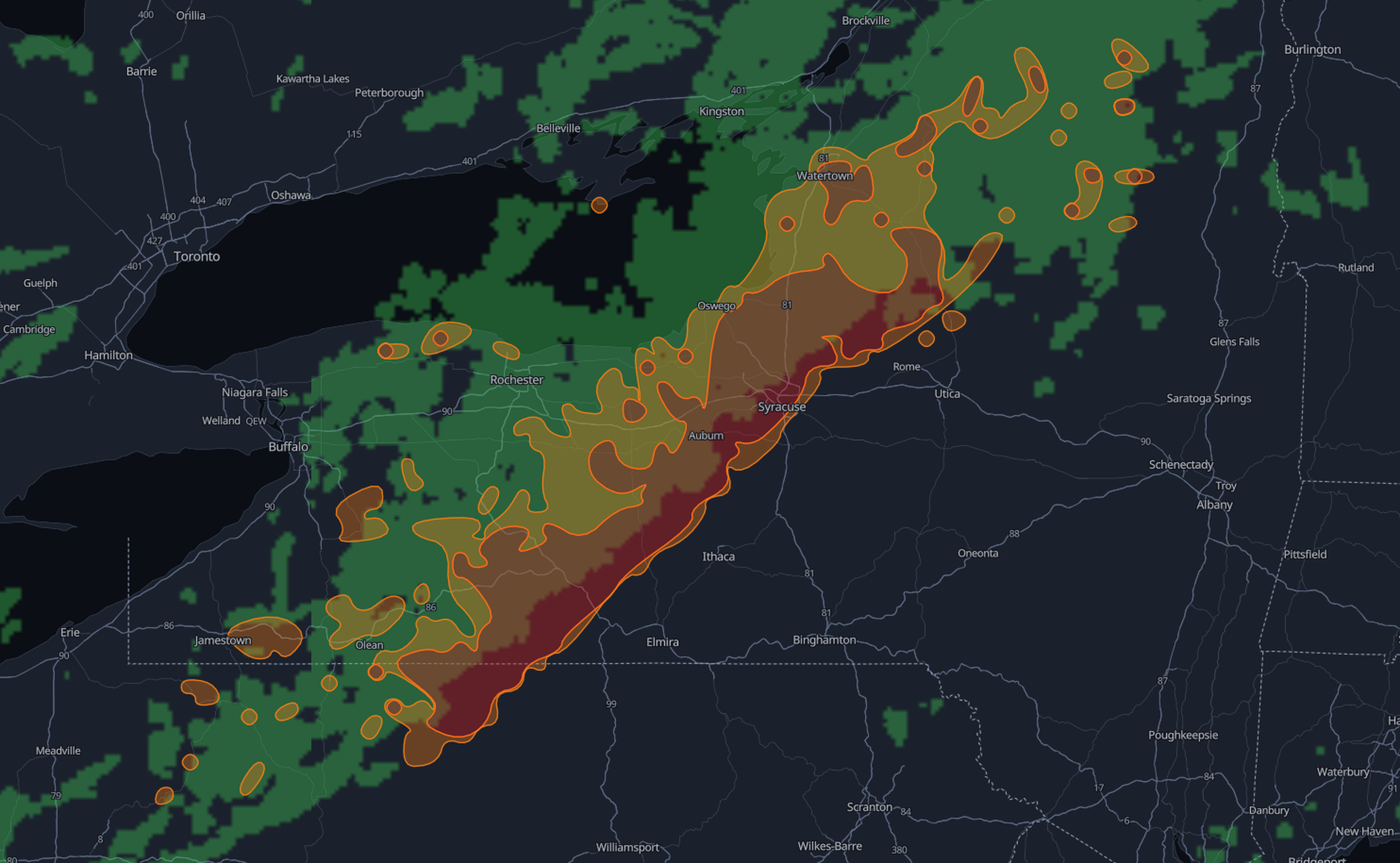
Driver Alerts is part of the Xweather Weather API Road weather family and answers two questions. The first question is simple: are there alerts here? Pass a city, a lat/long, or a US or Canadian postal code, and the API returns any alerts covering that location. That suits depot checks, dispatch decisions, and single-stop planning.
The second question is the one that matters most on the move: what will I drive through? Pass a set of coordinates along a custom route, and the API returns every alert that intersects it, from origin to destination. Fleet routing, delivery planning, and turn-by-turn navigation get a hazard picture for the trip itself, not just the endpoints.
Responses are served in standard JSON or GeoJSON, with the familiar filter and format parameters. There's no endpoint-specific syntax to learn. If you already call Xweather, Driver Alerts drops into the integration and the map layer you have.
What's in the data
These aren't county warnings redrawn on a map. Driver Alerts comes from Xweather's high-resolution road weather nowcast and refreshes every 15 minutes. It looks 15 minutes ahead for atmospheric hazards and 30 minutes ahead for road surface conditions.
Five hazard types are available at launch, each with published thresholds:
Alert type | Yellow | Orange | Red |
Slippery road | Snow/ice probability > 0.3 | Snow/ice probability > 0.5 | Snow/ice probability > 0.7 |
Heavy rain | – | ≥ 4 mm/hr | ≥ 8 mm/hr |
Low visibility | – | ≤ 400 m | ≤ 200 m |
High winds | – | ≥ 15 m/s | ≥ 25 m/s |
Blizzard | – | Wind ≥ 15 m/s and snow ≥ 2 mm/hr | Wind ≥ 15 m/s and snow ≥ 4 mm/hr |
Severity runs yellow, orange, and red, and each alert carries a plain-language description of the criteria, such as "visibility less than 400 meters." More road weather alert types are planned.
The design choices matter as much as the thresholds. The polygons don't overlap higher-severity areas are cut out of lower-severity ones, so any point falls within exactly one severity per hazard. An app never has to decide which of three stacked warnings to show. Only currently valid alerts are served, and each regional update lands as one consistent snapshot, never a partial mix of old and new. Geometry is opt-in for JSON, which keeps payloads small for mobile and in-vehicle use, while GeoJSON always includes it for mapping.
Coverage at preview spans the US and Canada, Europe, Japan, Australia, New Zealand, and South Korea. Driver Alerts is a value-added Xweather product. It complements official government warnings and doesn't replace them.
Built for dispatchers and drivers
For fleet and logistics operators, the route query is the headline. Dispatchers can check every leg for red and orange alerts before a truck leaves, push a warning to a driver already en route, and trigger a reroute when a new polygon crosses the planned path. This not only improves safety but also allows you to avoid unnecessary delays and liabilities proactively.
For navigation apps and in-vehicle systems, the value is in the shape of the data. Non-overlapping polygons with one severity per point are simple to render as a map layer and simple to turn into an audio or dashboard prompt. Small JSON payloads by default mean alerts can refresh on a phone or head unit without heavy data use.
For mobility platforms and ride-hailing services, Driver Alerts gives a short-term, driver-focused view to set expectations, adjust ETAs, and keep drivers informed. And for enterprise risk teams running travel safety dashboards or field operations, the same alerts can sit alongside the forecasts and warnings they already pull from the Xweather Weather API.
From general warnings to specific road hazards
Driver Alerts joins Xweather’s growing suite of road weather products, alongside pavement conditions and route forecasts. Most weather alerts are still designed for the public at large: broad areas, long time windows, and language written for everyone. Drivers, meanwhile, have been left to translate that information into a decision of their own, often at 65 mph.
Driver Alerts takes a different approach. It is scoped to the road, measured in minutes, drawn as a clean polygon, and ranked by a severity that maps directly to an action. It's delivered through the same API developers already use, so turning it into a live warning in an app, a dispatch rule, or a map layer is straightforward.
That's the direction we want to take road weather intelligence: less about describing the weather, and more about telling drivers what's coming and how serious it is.
Try it yourself
Check a drive from Minneapolis to Chicago for heavy-rain and high-wind alerts, returned as GeoJSON ready for your map:


