
Vaisala Xweather has developed a superior hail forecast based on lightning detection. In our last validation study, we found that Xweather correctly forecast 170 independently confirmed severe hail events with zero misses.
We have now expanded that exercise by validating our forecast against 3,659 confirmed severe hail reports from the U.S. in the first six months of 2026. This time we found that, in both accuracy and lead time, the Xweather hail forecast outperformed National Weather Service warnings and the radar-based method most commercial services rely on.
For solar farm operators, this means more time to stow and greatly reduced risk of hail damage. Let’s dig into the numbers.
Hail’s impact on solar projects
Hail is the leading cause of insured losses for solar farm operators. In its 2025 Solar Risk Assessment report, kWh Analytics states that hail accounts for 73% of total losses, despite representing only 6% of loss incidents.
VDE Americas notes that hail damage represents 2% of solar project insurance claims but comprises over 50% of the total costs, an average of roughly $58 million per claim. Hail damage reported to AXIS Capital alone amounted to $340 million between 2019 and 2024.
PV panels mounted on tracker systems (to follow the sun) can be tilted to towards vertical when there is a risk of severe hail. Moving the panels to a defensive stow position reduces the risk of damage significantly. One study found that stowing modules at 60° during a hailstorm increases the survivability of the PV panels from 81% to 99%. Some of the latest trackers now offer fast stows at up to 80 degrees and systems that remain operational even when there is a grid outage.
Stowing is effective, but it relies on having enough lead time to act before the storm arrives. That’s why an accurate hail forecast is essential.
Building a more accurate hail forecast
Forecasting hail is one of the toughest problems in meteorology. Standard weather models and weather radar have known limitations when it comes to predicting and observing the intricate processes that govern hailstone formation.
A better approach starts with the simple fact that hailstorms are always accompanied by lightning. Inside a storm cloud, the same convective processes that generate lightning can also form hailstones. By detecting that lightning, we're observing the dynamics that produce hail before the stones grow large enough to fall.
Fusing lightning data into the Xweather forecast model produces a unique, highly accurate hail forecast that updates every 2 minutes and provides up to 60 minutes lead time.

The Xweather hail forecast (purple polygons) updates 30 times per hour and provides up to 60 minutes lead time. NWS Severe Thunderstorm Warnings (yellow polygons) update 1–3 time per hour and provide roughly 30 minutes warning.
Benchmarking the Xweather hail forecast against radar and NWS warnings
For this validation, we compared three approaches to hail forecasting:
Xweather hail forecast: a continuously updated hail forecast built on lightning data, fused with radar, satellite imagery, and numerical weather models. It refreshes every 2 minutes with the probability of severe hail, time of arrival, approach direction, and up to 60 minutes of lead time.
MRMS MESH 1”+: the radar-based method behind most commercial hail-alerting services. MRMS (Multi-Radar Multi-Sensor) mosaics NOAA's national radar network and other sources into a single, seamless view. From that data, MESH (Maximum Estimated Size of Hail) estimates hail diameter. A hail diameter of 1” or greater was used for the comparison.
NWS Severe Thunderstorm Warnings: the official warnings issued by the National Weather Service, triggered when a forecaster determines a thunderstorm has met severe criteria (1-inch hail or greater and/or 58 mph wind). Each warning carries a single hail-size and timing estimate that holds for its full duration, and new warnings are issued 1 to 3 times per hour.
To validate these forecasts, we retrieved 3,659 severe hail reports from NOAA’s Storm Prediction Center for the first six months of 2026. These hail reports come from trained spotters, sensor networks, and public submissions to crowd-sourced platforms.
Across the contiguous United States, 68% of utility-scale solar sites sit within 30 miles of one or more of these events, but the true risk is far greater. The coverage of human-reported hail events is sparse, uneven, and often entirely absent in the remote locations where solar projects typically sit. The 3,659 reports used in this study cover only a tiny fraction of the hail that actually fell in the first half of the year.
However incomplete the overall sample, we know that each report is a confirmed ground-truth observation. Using a 30-mile buffer around each location, we ran the data to determine if and when each forecast would have predicted severe hail.
Hail forecast accuracy validation results
The Xweather hail forecast outperformed both the public benchmark and the industry's dominant commercial method on every measure tested. It detected more severe hail and earlier.
Across the first half of 2026, the Xweather forecast predicted 99.2% of the reported severe hail events, a near-perfect result that significantly reduces hail risk for solar operators.
National Weather Service severe thunderstorm warnings forecast 93.1% of the confirmed events. MESH, the radar-based hail-sizing method behind much of the industry's commercial alerting, detected just 83.3%, missing roughly one in six storms outright.
The Xweather forecast also provided more advance warning, achieving the highest mean lead time at 53 minutes, against 50 minutes for MRMS and 30 for NWS. While the MRMS average lies close to the Xweather result, it exhibited a much wider spread of results compared with the tight distribution of Xweather lead times.
Xweather provided at least 15 minutes warning for over 95% of the severe hail events, while MRMS trailed at 72.2%, a drop of over 20%.
The Xweather advantage was even more pronounced at longer lead times, providing at least 45 minutes warning in 82.9% of cases, while MRMS fell far behind and met the threshold in just 45.2% of cases. The NWS warnings were able to provide 45 minutes or more lead time in only 16.6% of cases.
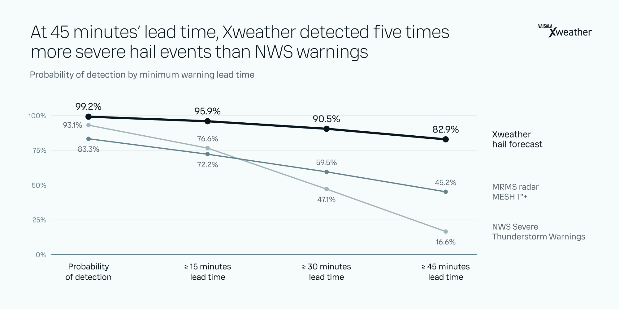
Hail forecast performance for 3,659 severe hail events in the contiguous United States reported by NOAA Storm Prediction Center from January 1 to June 30, 2026
Vaisala Xweather hail forecast | MRMS radar | NWS Severe Thunderstorm Warnings | |
|---|---|---|---|
Probability of detection | 99.2% | 83.3% | 93.1% |
Mean lead time (sd) | 53 (13) min | 50 (28) min | 30 (15) min |
≥ 15 minutes lead time | 95.9% | 72.2% | 76.6% |
≥ 30 minutes lead time | 90.5% | 59.5% | 47.1% |
≥ 45 minutes lead time | 82.9% | 45.2% | 16.6% |
Know when to stow
A dependable hail forecast lets operators automate stow decisions, reducing the risk of a missed or late response. When hail is forecast near the site, an alert triggers the stow. Xweather Protect provides a ready-built solution for hail alerts and severe weather risk management, while our Weather API gives operators the flexibility to integrate hail forecasts and alerts into existing systems.

When a hail forecast intersects the buffer zone around an asset, Xweather sends an alert with the probability of severe hail, time of arrival, storm approach direction, and the recommended stow direction.
VDE Americas suggests that effective stow reduces typical losses from ≥ $50 million to less than $5 million, while AXIS Capital reports claim severity is halved with successful stow.
Insurers are starting to notice and offer better rates to sites with a reliable stow protocol. One Texas operator cut its insurance premium by 72% after proving a 90% stow rate against past hail events, according to kWh Analytics.
When a single hailstorm can trigger an eight-figure claim and take a site offline for months, every additional minute of warning can make a difference. An operator running on radar is working from a forecast that misses roughly one in six hailstorms outright. Xweather’s unique lightning-based hail forecast alerts close that blind spot almost entirely, correctly forecasting 99.2% of severe hail events and outperforming radar by 15.9 percentage points. For solar operators, that means more time to stow and a materially lower risk of hail damage when the storm arrives.


