)
)
Synergizing advanced weather forecasting and sensor expertise, the Xweather's road weather API offerings bring precise, timely road weather data and a detailed understanding of road conditions to the table — Just what you need to ensure safer journeys and enhanced performance for vehicle and fleet management systems.
Road weather conditions: Navigate the weather with confidence
Road travel efficiency is fraught with uncertainty when the weather comes into play. To tackle this, we've introduced the roadweather/conditions endpoint, empowering drivers with critical information about the road conditions ahead.
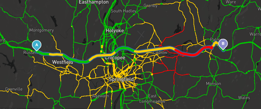
It uses an intuitive color-coded system - green, yellow, red - to determine safe conditions at a glance.
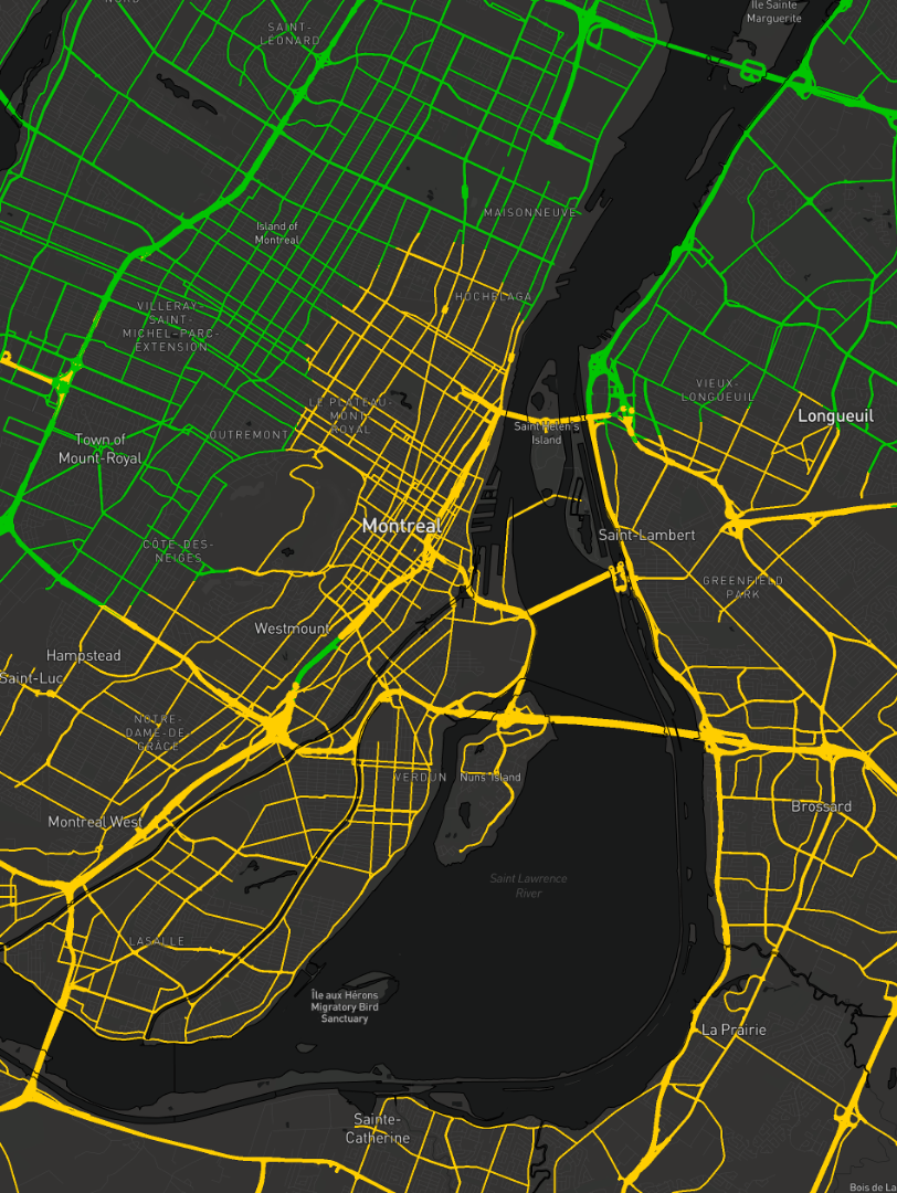
Road Weather Summary in Montreal, Canada
Green means no significant risks – the roads are dry and pose no issues.
Yellow serves as a warning – drivers should be aware of potential risks such as hydroplaning due to wet roads.
Red signals danger – expect risks such as hydroplaning or snow and ice on the roads.
Straightforward, isn't it? Behind the scenes, it's powered by complex weather modeling and machine learning algorithms. The resulting tool delivers concise, actionable insight to improve road safety and route planning.
The best part? The roadweather/conditions endpoint is available to all Flex subscribers directly through their existing subscription.
Use roadconditions/summary to enhance route and ETA planning, drive with confidence, and ensure safety - no matter the weather.
Comprehensive road weather data for every journey
Navigating the roads safely requires more than just understanding the current weather. It demands a detailed understanding of how weather affects road conditions.
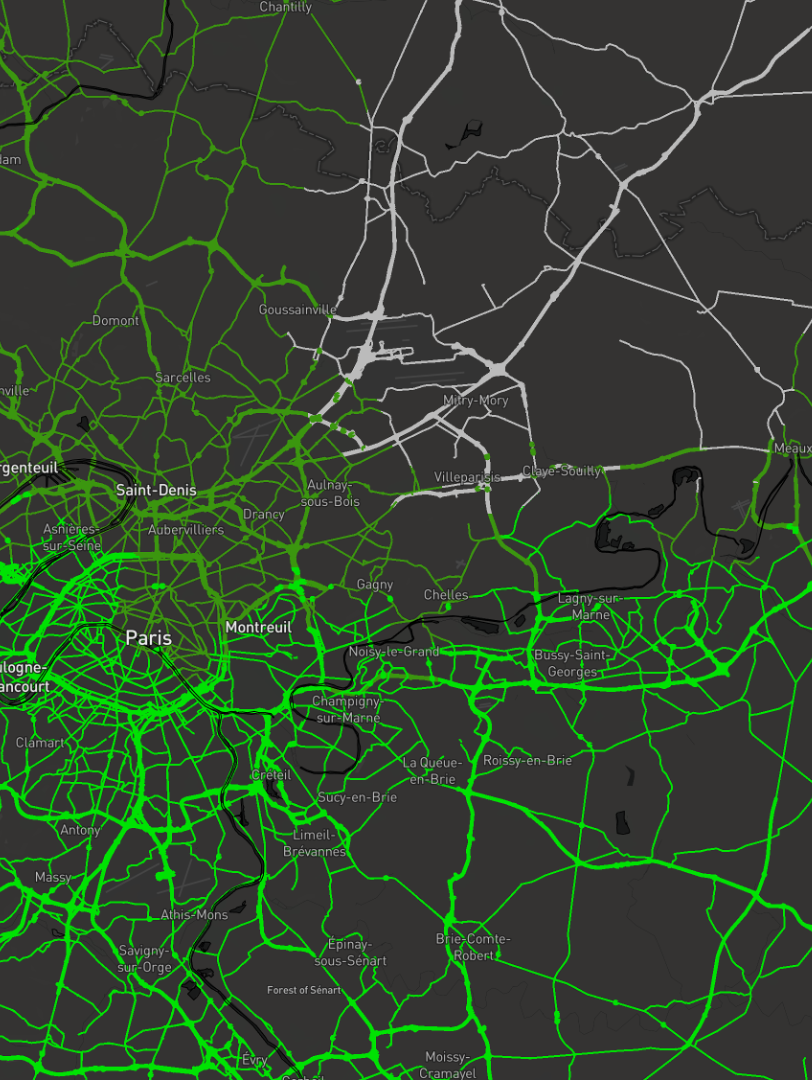
Road Surface Conditions in Paris, France
Beyond road weather conditions, our road weather API offerings now include specific road conditions like dry, wet, slushy, snowy, and icy, accessible through the roadweather endpoint. These inputs paint a clear picture of what to expect on your route, but the depth of our data doesn't stop there.
The Xweather API also provides road surface temperature, friction estimates, and water, snow, or ice thickness via the the roadweather/analytics endpoint. This granular data helps plan routes more effectively and make better-informed decisions.
Why road weather data matters
Accurate, real-time road weather data can drastically improve road safety and driving comfort. Wet conditions, for instance, are responsible for nearly three-quarters of all weather-related road accidents. By providing data on water film thickness and friction, our road weather API insights help drivers adapt to these conditions and mitigate risk. Similarly, forecasts for snow and ice support safe navigation in colder climates, reducing the incidence of weather-related accidents.
Summarizing road weather API data accessibility
Our road weather API data can be accessed via three different endpoints:
The
roadweatherendpoint includes access to road conditions summary and indexThe
roadweather/conditionsendpoint builds on theroadweatherendpoint with road surface condition and temperatureThe
roadweather/analyticsendpoint provides additional insights such as water, snow, and ice thickness and risk probabilities such as hydroplaning and low visibility conditions
Make the most of road weather data
Tap into the most reliable and abundant data for any journey using the roadweather endpoint. Detailed endpoint information is available in the roadweather endpoint documentation.
Here's an example of querying the API:
The roadweather endpoint shines in its utility when used in conjunction with the Xweather API's route action, which fetches weather and road weather information along a predefined journey, making it perfect for in-vehicle navigation systems. You can see this powerful combination in our road weather routing demo.
Finally, the data isn't just accessible via the API, but also in MapsGL, with a number of road weather summary and surface condition layers providing versatile and comprehensive road weather data available to all MapsGL subscribers. These layers help to meet a wide array of both visual and data needs. Moreover, road weather data is compatible with 3D views in multiple mapping libraries such as MapBox and Map Libre, offering visually engaging and interactive ways to understand road conditions.
Driving forward
Our weather API and MapsGL provide detailed road weather responses, offering data from road type and name to advanced road surface information and risk probabilities. These provisions cater to various use cases — from infotainment and driver support to advanced driver assistance systems (ADAS), autonomous driving (AD), vehicle systems optimization, and fleet management.
Explore the potential of road weather and road surface data for yourself today with a free 30-day trial of our weather API, Raster Maps, and MapsGL offerings, or get in touch to discover how our advanced road weather data can improve safety and efficiency for your road-based operations.
)