We know when lightning strikes
The Xweather lightning API delivers the precise location and characteristics of every lightning strike globally. With over 40 years of lightning detection experience, no other company can match Vaisala for quality, accuracy, and coverage. Vaisala is the primary source of lightning data for the U.S. Armed Forces, National Weather Service, Federal Aviation Administration, and many international commercial organizations.
The global lightning detection leader
We detect the precise time and location of over 2 billion lightning events every year.
Lightning API endpoints
Explore endpoints for monitoring, analyzing, and summarizing lightning activity.
lightning
The lightning endpoint delivers near real-time, high-resolution, global lightning strike data—including type, location, and intensity.
What it delivers:
Global, real-time lightning detection with detailed strike characteristics, optimized for localized awareness and rapid response.
Up to 1,000 events from the past 5 minutes within a 100 km radius
Strike details include type (cloud-to-ground or intracloud), location, polarity, and amperage
lightning/flash
The lightning/flash endpoint provides real-time data on individual lightning strikes for immediate awareness and action.
What it delivers:
Real-time data on individual lightning flashes, with precise metadata for location, intensity, and strike type.
Each flash includes timestamp, location, type (cloud-to-ground or intracloud), polarity, and peak amperage
Standard access: Last 5 minutes, 100 km radius, up to 1,000 events
Enterprise access:
Up to 24 hours, 500 km radius or polygon, 50,000 events
lightning/threats
The lightning threats endpoint identifies and tracks active lightning hazard zones, providing real-time, area-based insights that go beyond individual strike data.
What it delivers:
A stream of GeoJSON-formatted polygons identifying lightning threat zones, each annotated with a threat status and timestamp for time-based tracking.
Each polygon is classified as new, persistent, dissipating, or cleared, based on ongoing lightning activity and storm trajectory
Polygons dynamically reflect storm evolution and typically span 5–100 km in diameter, depending on storm size and movement characteristics
Refreshed every 1–2 minutes using real-time lightning detections and automated storm clustering algorithms
lightning/summary
The lightning summary endpoint delivers a real-time, global snapshot of recent lightning activity for quick assessments and situational awareness.
What it delivers:
Global overview of lightning pulses and strikes from the past 24 hours. Supports location-based queries (by city, coordinates, or closest match)
Ideal for dashboards, visualizations, and operational alerts that rely on lightning density or frequency—not individual strikes
lightning/archive
The lightning/archive endpoint delivers detailed historical lightning strike data from 2016 to the present, enabling deep analysis of past weather events.
What it delivers:
A JSON response with up to 1,000 lightning events per request, each including timestamp, location (lat/lon), type (CG or IC), polarity, peak amperage, and multiplicity (if available).
Supports 24-hour time windows, 100 km radius, pagination via skip, and access to data from January 1, 2016 onward.
Precision lightning data for your application
Access lightning data the way you need it through our weather API, webhooks, raster maps, and MapsGL.
Weather API
The Xweather Lightning API is a RESTful service providing precise global lightning data for seamless integration into web, native, or mobile applications.
Webhooks
Get near real-time lightning data via webhooks. Just provide an HTTP URL, and our system will push data from any lightning endpoint to your application.
Maps
Monitor approaching storms near critical assets with our weather mapping platforms. Build applications with full weather maps or transparent tiles, compatible with Leaflet, Mapbox, and more.
Unlock deeper lightning insights with the enterprise access
Lightning Enterprise add-on
The Lightning Enterprise add-on unlocks the full potential of Vaisala Xweather’s global lightning detection network. It’s designed for organizations that need more context, more history, and more coverage to make smarter, safer decisions—especially in high-risk or weather-sensitive environments.
Larger coverage area
Higher data volume
Includes detailed metadata:
– Type (cloud-to-ground or intracloud)
– Polarity and amperage
– Precise locationCustom queries, webhook delivery, and more – contact sales to discuss custom options
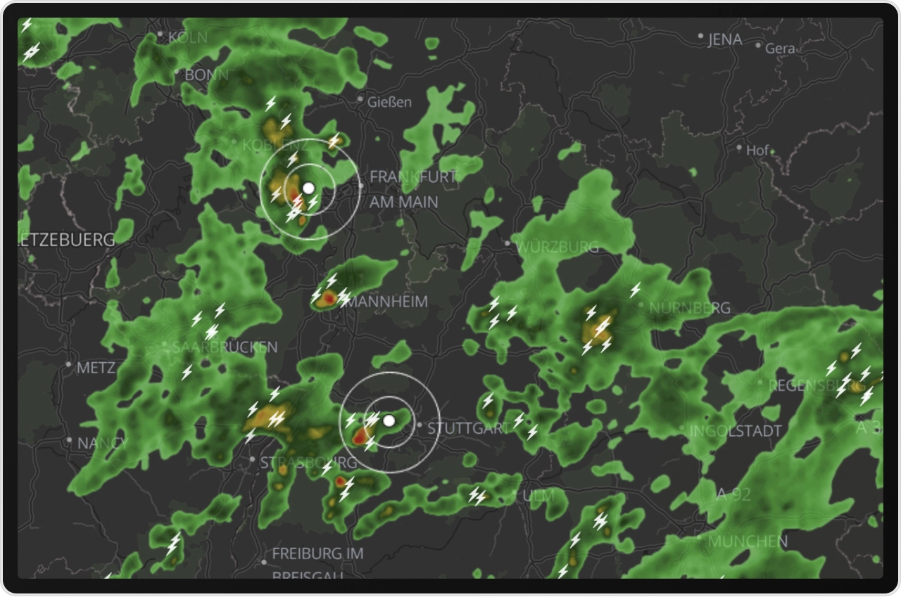
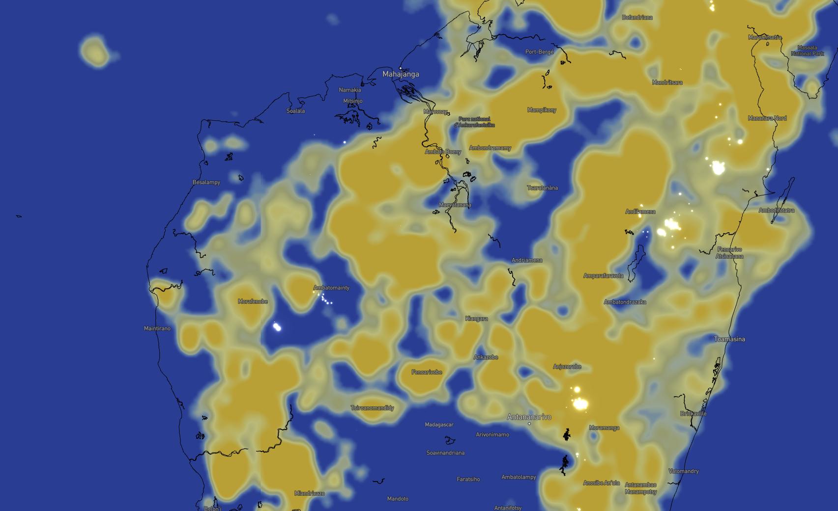
Visualize lightning threats in stunning clarity
Harness our API-powered MapsGL vector mapping platform to create stunning visuals of lightning and other weather threats.
Smooth animations
Overlay our gorgeous, comprehensive animations with a map of your own critical assets to contextualize lightning data at a glance to quickly understand potential impacts.
Full customization
From colors and animations like flashes, adjust your lightning display on the go to suit your application’s needs.
Weather API subscription
The Weather API subscription includes all lightning data endpoints — plus access to high-resolution lightning visuals with Raster Maps and MapsGL and easily readable weather summaries from the Phrases API.
Get started with a free 30-day trial.
Talk with an expert
Whether you're exploring the Weather API or ready to unlock enterprise-level lightning access, we're here to help.