Learn about Madison County's experience deploying RoadAI
We collaborated with road asset management expert John Rondinaro to deep-dive into best practices and challenges in pavement inspection.
After a long career with the New York State Department of Transportation (NYSDOT), John is currently a Pavement Consultant in New York State.
John retired in 2020, after 36 years with NYSDOT. In the late 1990’s, John served as the DOT HQ Pavement Engineer, and in the early 2000’s John was appointed as NYDOT’s Director of Materials Engineering.
As the Materials Engineering Director, John oversaw the NYSDOT Pavement Management organization and activities. In that role, John had extensive involvement in NYSDOT’s Asset Management efforts – including pavement data collection and network condition analysis, capital program development, and project-level treatment selection - as well as design, construction, and maintenance project support.
In this article John interviews Bart Walls, Highway Superintendent of Madison County, TN, about his experience getting started with RoadAI and first impressions of their newly-developed road asset inventory practices with an automated tool.
Tell us a bit about Madison County's road network
Madison County is located in the central part of West Tennessee with 3 municipalities within it: The city of Jackson, the city of Three Way, and the city of Medon. The primary town is the city of Jackson.
The city of Jackson is located on Interstate 40, which goes right through the center of the town, bringing high traffic. The city's road network consists mainly of the low volume rural county roads, two-lane roads, most of which are chip seal. All in all, we are responsible for about 690 miles of roads with 213 bridges. The majority of the roads are chipseal, and that's primarily what we work on and perform maintenance on.
What is your primary reason to collect pavement and asset data and what do you want to use that data for?
Ever since I've been Highway Superintendent, those were all gut decisions made by myself or my predecessors. Sometimes those decisions were political. Sometimes they were engineering judgments. Given the times that we are in, everything is becoming much more data-driven; so we are trying to adjust and become more data-driven ourselves.
Prior to RoadAI we were not collecting any information on our road system. We weren't assessing the roads other than just looking at them and saying “Yep, we need to do some work on this road” or “We need to pave this road”.
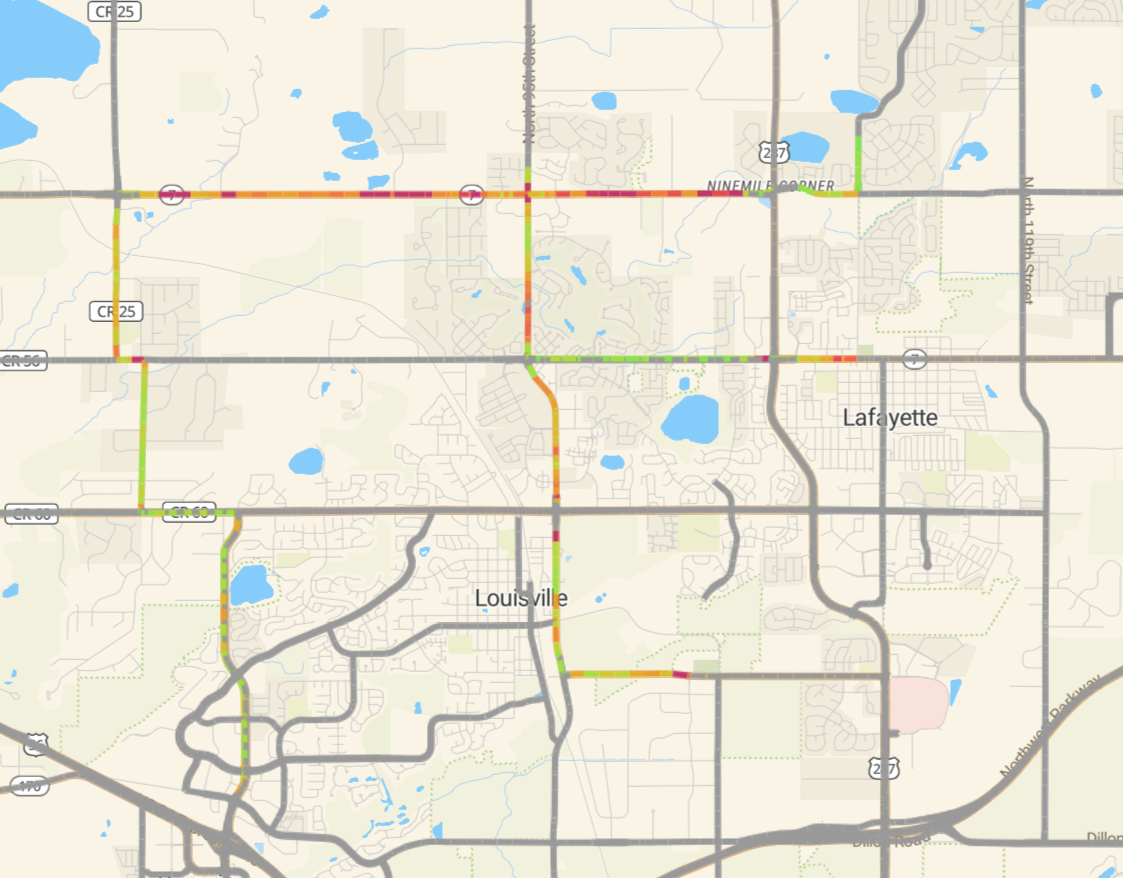
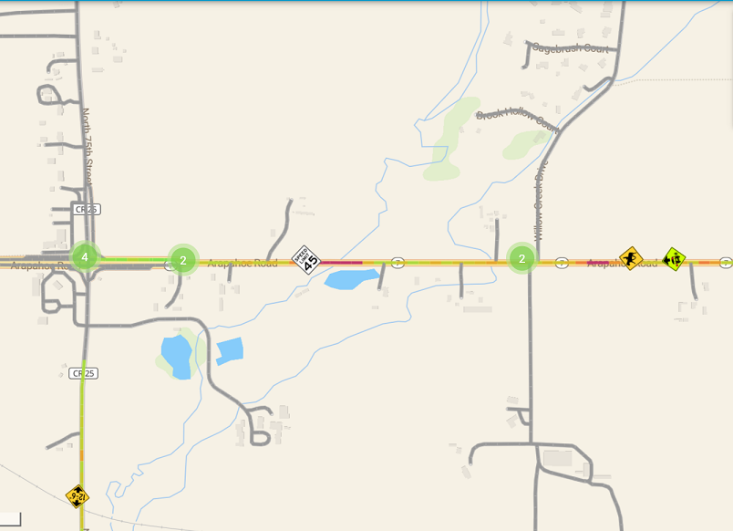
Road Surface Condition Heatmap in the RoadAI User Interface. The heatmap shows a gradient score of the road condition data based on calculated Pavement Condition Index. This allow users to have an updated status of the condition of their entire network. Green is closer to a 100% PCI score, while red is closer to a 0% PCI score.
We want to start putting together a 3-year plan: how we are going to work on our roads, how to pave them. We started looking into some kind of Pavement Management System, whether it be PASER (Pavement Surface Evaluation & Rating) or Pavement Condition Index (PCI). We knew we needed to start collecting information on our road system.
And as an engineer, I wanted that data to be automated and I wanted to be able to collect data when I wanted to, and as often as I wanted to, to see how my roads are doing, and so that's what really led me to RoadAI.
Bart Walls, Highway Superintendent - Madison County, TN
I looked at several different products and test-drove a few and - based on several factors - decided that RoadAI was the best fit for us. So, we partnered with RoadAI and begun this journey of data collection, figuring out how to use the data to improve our community and our road system.
What characteristics of RoadAI seemed the most important to you in your decision-making?
We've been using RoadAI for a few months now, and we have most of our roads driven. We're now collecting data in some of subdivisions on little dead-end roads here and there to out our data collection.
I like the graphical interface; it allows me to see a map of our roads and see what condition our roads are in. I also appreciate having a pavement condition index (PCI) assigned to each road. I can isolate sections of my roads and just look at part of a road instead of looking at the entire road and see the PCI of a particular section. Or if I wanna know the PCI for my entire county, I can do that as well.
I do like the fact that RoadAI allows us to collect the data ourselves instead of a consultant who comes in and collects it for us. So, if I want to collect data more than once a year, I can.
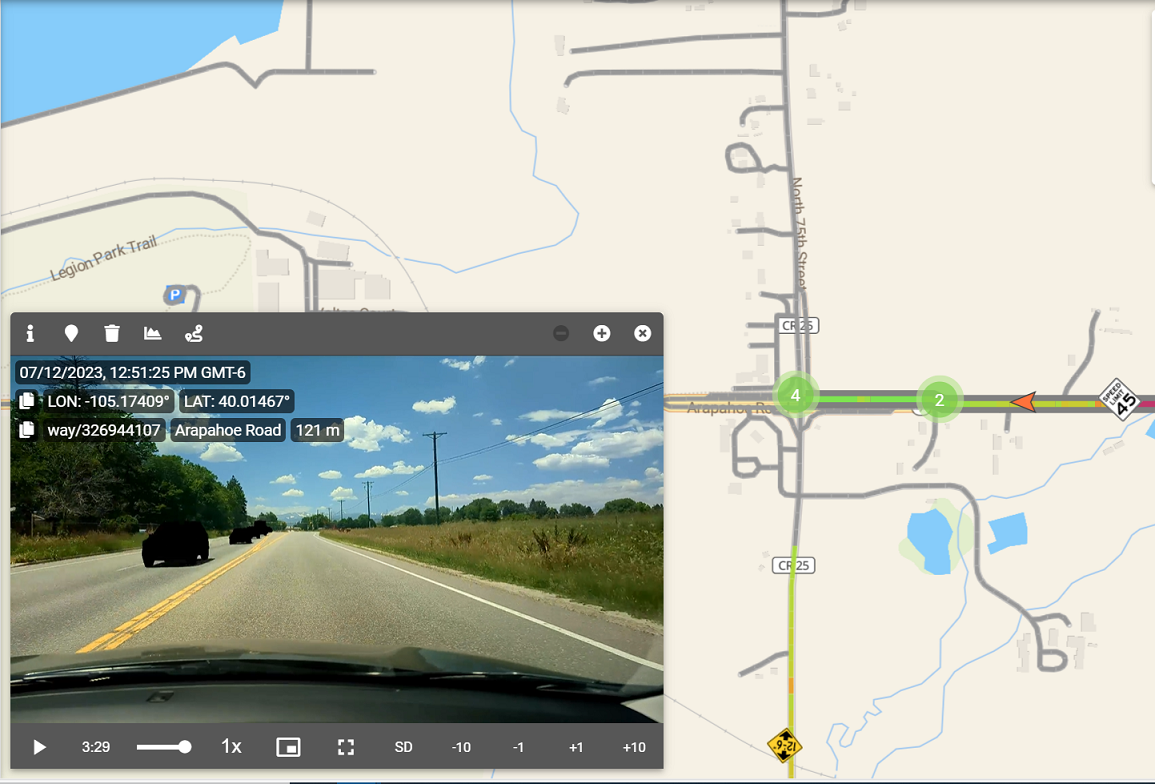
Video playback feature in the RoadAI User Interface.
Another reason I chose RoadAI was its ability to have the data updated regularly. When you make your own road assessment using for example PASE, that's really just a snapshot. A one-time snapshot in time of what your road system is like at that moment - three years from now is not going to be accurate anymore. It may be fairly close, but it's not going to be really accurate. The thing I like about the RoadAI is if I wanna drive my roads more frequently to see where we're at, I can.
What's your experience getting started with RoadAI and how do you feel about the solution do far?
Getting started was very simple. We received a cell phone with a windshield mount and a polarized windshield sheet for to help cut down on glare. It only took a few minutes to get everything set up properly, and then it was just a matter of installing the software on the phone.
And then we just hit the road! We went out and drove the roads for a day. When we got back to the office and connected the phone to Wi-Fi the videos uploaded to the server automatically. The next morning those videos were already processed, giving me the data I canwork with.
.. you don't necessarily have to have a high-level person, or an engineer, go out and collect the data. It can be anyone, an equipment operator or an office assistant. Or maybe your county mayor who wants to drive the roads and see what they're like. Anybody can do that, there's no training required.
Bart Walls, Highway Superintendent - Madison County, TN
We're just getting started and still figuring out how we want use the data. No two organizations that are the same, not everybody is going to use the data exactly the same way. I look forward to figuring out what's the best way for us to use it and maybe we can help some other folks along the way to do the same.
I also want to mention that RoadAI team has been wonderful in supporting us. We set up regular meetings to discuss how we're doing, how we're looking at the data, and how to generate reports and things like that.
Is there anything else you want to share about your recent expereince with RoadAI?
Having video data of the entire road network has proved useful in cases that have nothing to do with road conditions per se. So when someone calls on the phone and says, “Hey, we got an issue on such and such road”, and I can pull the video up and see what's going on. That video is fairly recent, I can pull up thesection of road in question and look at what the recent condition is.
We've recently had a disaster going on with Federal Emergency Management Agency (FEMA), and having recent video data of every road condition is a huge help since FEMA will only pay for putting your roads back to pre-disaster conditions. So, if you don't have photographic or video evidence of pre-disaster conditions it's your word against theirs. Luckily, we now have RoadAI video data to show what the condition of a certain road was pre-disaster.