Historical solar irradiance data
Unlock the full potential of your solar energy projects with high-resolution solar time series data and standardized Typical Meteorological Year (TMY) datasets.
25+
years of time series data with monthly averages.
250+
sites around the world providing reference data for validation.
10-minute
resolution for sub-hourly time series data.
High-quality solar irradiance data for resource assessment
Unlock the full potential of your solar energy projects with high-resolution solar time series data for precise resource assessment and performance monitoring, alongside standardized Typical Meteorological Year (TMY) datasets for robust financial analysis, risk analysis, benchmarking, and regulatory compliance.
Use our Solar prospecting maps for a quick look at long-term average solar resources and our solar time series tools to visualize and order hourly and sub-hourly time-series data. The data sets are based on historical satellite imagery and cutting-edge technology offering over 25 years of hourly GHI, DNI, DIF, and other key weather variables. We provide hourly data as well as sub-hourly data at 10, 15, and 30-minute resolution.
Key features
Global coverage
Explore solar data for locations with a spatial resolution of 2 arc minutes (~3 km). Xweather provides worldwide coverage from 60° N to 48° S.
High-resolution history
Over 25 years of precise solar and weather parameters at sub-hourly (10, 15, 30 minutes) and hourly resolution for any location.
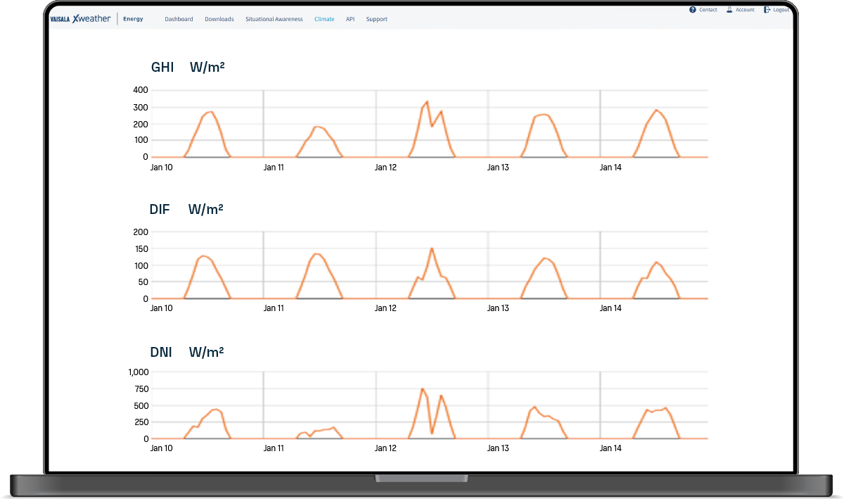
Complete set of parameters
Industry-standard solar parameters including GHI, DNI, DIF, and albedo with additional weather variables such as temperature, wind, humidity, precipitation, and more.
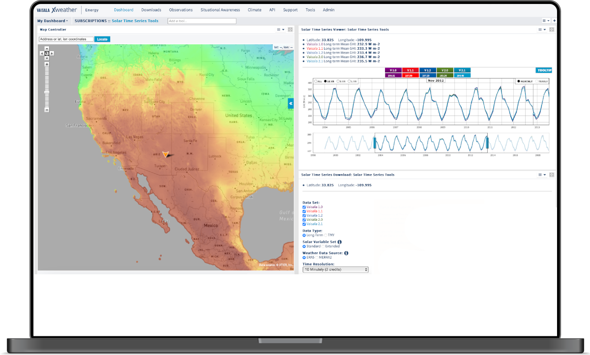
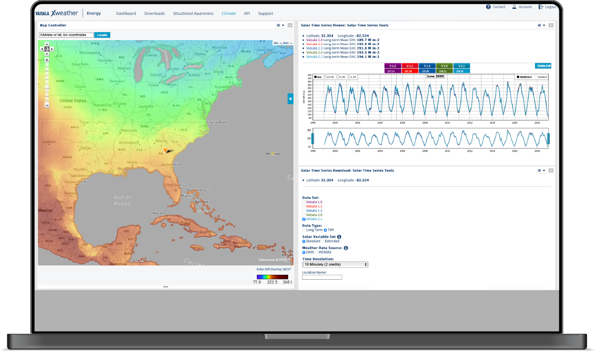
Solar time series data
Time series data is essential for accurately assessing the solar energy resources at a specific location to identify sites for solar energy projects and estimate their potential yield.
Xweather solar time series data provides over 25 years of precise solar and meteorological parameters at sub-hourly (10, 15, 30 minutes) and hourly resolution for any location.
TMY solar datasets
A Typical Meteorological Year (TMY) dataset represents the typical conditions at a site over 12 months. providing a valuable input for design and simulation, risk assessment, and financial analysis.
Xweather solar TMY datasets cover a complete year with an hourly resolution. We use a proprietary method that prioritizes matching GHI and DNI to their long-term historical averages.
The 1-month mean value of our TMY datasets matches the long-term monthly mean to within 0.5% for GHI and 1% for DNI. The 12-month mean matches the long-term annual mean to within 0.3% for GHI and 0.5% for DNI.
Solar reconciliation API
Reconciliation compares your solar project's actual energy production with its expected energy generation. Reconciliation helps solar energy operators assess the accuracy of their energy production forecasts, identify areas for improvement, and optimize revenue management strategies.
The Xweather solar reconciliation API provides a daily feed of yesterday's data to reconcile operational power performance for specific locations on an ongoing basis.
The API provides GHI, DNI, DIF, temperature, wind speed, wind direction, pressure, humidity, precipitation, and snow/ice with sub-hourly or hourly resolution.
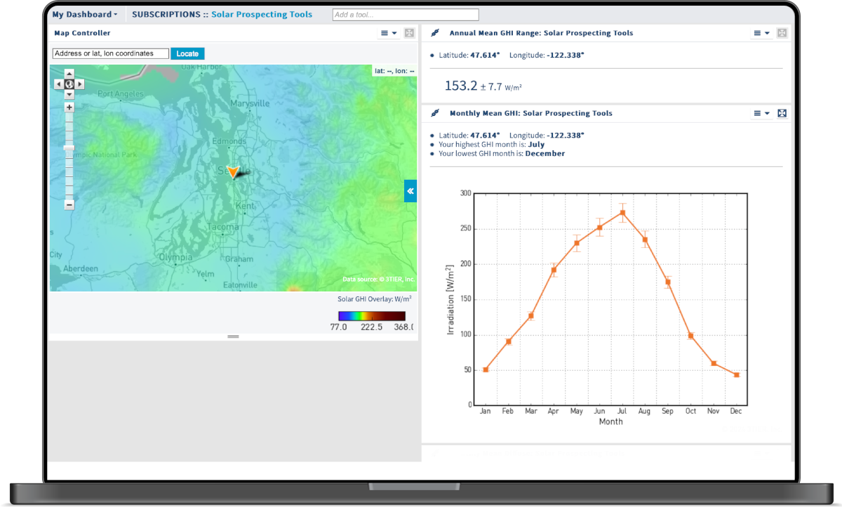
Solar prospecting maps
Xweather solar prospecting maps provide fast and easy access to long-term average solar resource data for site assessment and prospecting. Create eye-catching plots of the 10-year average GHI, DNI, and DIF from the proprietary Vaisala 1.0 data set and explore monthly Global GHI averages in the Xweather energy portal.
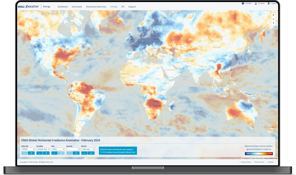
Climate reference tool
Explore over 40 years of historical wind, solar, and temperature data. The Xweather Climate Reference Tool shows departures from the long-term average for the last month, quarter, and year.
The data covers the entire globe and includes temperature, wind speed (at 100 m), direct normal irradiance, and global horizontal irradiance. We have over 40 years of historical data available, which you can view by month, quarter, or year.
Minimize development risk
Use the most reliable, high-quality solar resource data right from the start to avoid sudden shifts in resource uncertainty or energy estimates that can make or break a project down the pipeline.
Cost-effective subscription access
Download hundreds of data files with all the solar resource and weather variables you need for a single annual fee to reduce your development costs without settling for low-quality data.
Data when you need it
Moving at the speed of solar development, long-term time series and TMY data are delivered to you in as little as 10 minutes, so you can meet tight deadlines.
Get started today
Standard
Explore hourly data for GHI, DNI, DIF, albedo, and a range of essential weather parameters in the Xweather energy portal
Download solar resource time series data with 10, 15, 30-minute, or hourly resolution as CSV files
Download TMY datasets as CSV files
API access to solar time series and TMY data
Solar prospecting maps
Climate reference tool
Dedicated account manager
FAQs
What affects solar radiation at a site?
What is Global Horizontal Irradiance (GHI)?
What is Direct Normal Irradiance (DNI)?
What is Diffuse Horizontal Irradiance (DIF)?
What is albedo?