WeatherBlox - Tropical
TropicalObject
aeris.wxblox.views.TropicalData Usage
/tropicalcyclones (1)
Raster Maps usage based on size of map and total layers.
Raster Maps usage based on size of map and total layers.
The Tropical view displays a variety of view types depending on the desired output using the viewType configuration option.
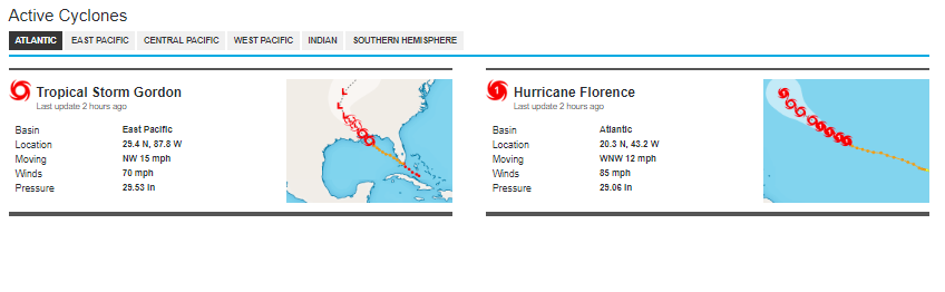
Examples
Display the active tropical systems for the current season in a single listing:
const view = new aeris.wxblox.views.Tropical('#wxblox');
view.load();
Display the active tropical systems for the current season in a tabbed format:
const view = new aeris.wxblox.views.Tropical('#wxblox', {
    show: {
        tabbed: true
    }
});
view.load();
Display all tropical systems for the current season in a single listing:
const view = new aeris.wxblox.views.Tropical('#wxblox', {
    viewType: 'archive'
});
view.load();
Display all tropical systems for 2005 in a tabbed format:
const view = new aeris.wxblox.views.Tropical('#wxblox', {
    viewType: 'archive',
        year: '2005'
});
view.load();
Display the full track for a specific tropical system (example uses Katrina):
const view = new aeris.wxblox.views.Tropical('#wxblox', {
    viewType: 'track'
});
view.load({
    p: '2005-AL-12'
});
Configuration
The following configuration options are supported by this view:
| Option | Description | Default |
|---|---|---|
viewType | Type: string () | |
year | Type: string () | |
basins | Type: string () | |
reversed | Type: boolean () | |
maps | Type: object () | |
show.title | Type: boolean () | |
show.empty | Type: boolean () | |
show.tabbed | Type: boolean () | |
show.maps | Type: boolean () | |
show.links | Type: boolean () | |
enabled | Type: boolean () | |
metric | Type: boolean () | |
renderNoData | Type: boolean () | |
request | Type: object () | |
Methods
The following methods are supported by instances of this view:
rendered()show()hide()params()setUnits(:number)units()enabled()setMetric(:boolean)load(:object)refresh()isMetric()Events
The following events are triggered by instances of this view:
renderrender:beforerender:afterload:startload:doneload:errorchange:units