
Like any art, creating something magical requires the best tools for the job. For instance - if you’re sanding a table or building a deck, you want to use the best tools at your disposal. So it goes with weather forecasting. Meteorologists examine scores of regional and global models for consistency, continuity, and trends, ultimately choosing a blend of model solutions that create a forecast with the highest probability of coming true. (Believe it or not, meteorologists want to get the forecast right!)
Forecasting systems: ECMWF vs. GFS
When it comes to global weather forecasting, there are two primary systems:
ECMWF, or the “European Model”, run by the European Centre for Medium-Range Weather Forecasts out of Reading, England, and
GFS (Global Forecast System), the "American Model"
Of course, many meteorologists have their preference, but those preferences will likely be based on what works based on a combination of facts and personal experience. Over time, many meteorologists have reached the same conclusion, and that's this: ECMWF - the European model - is consistently more accurate. Not perfect, but it does generate better weather prediction in most real-world scenarios — and those are the ones that count.
At the risk of oversimplification, there are many reasons why ECMWF is more accurate. Unlike NOAA, the U.S. National Oceanic and Atmospheric Administration, which runs dozens of models including GFS, ECMWF runs one global model at high resolution. All efforts and resources have been focused on perfecting this one weather simulation. There are other factors involved, including demonstrably better data assimilation (in plain words: getting the most recent observations into the ECMWF model faster) and a steady pipeline of meteorological research (and better physics) being applied to improve the ECMWF model at a quicker pace. The result: ECMWF is arguably the best weather model on the planet.
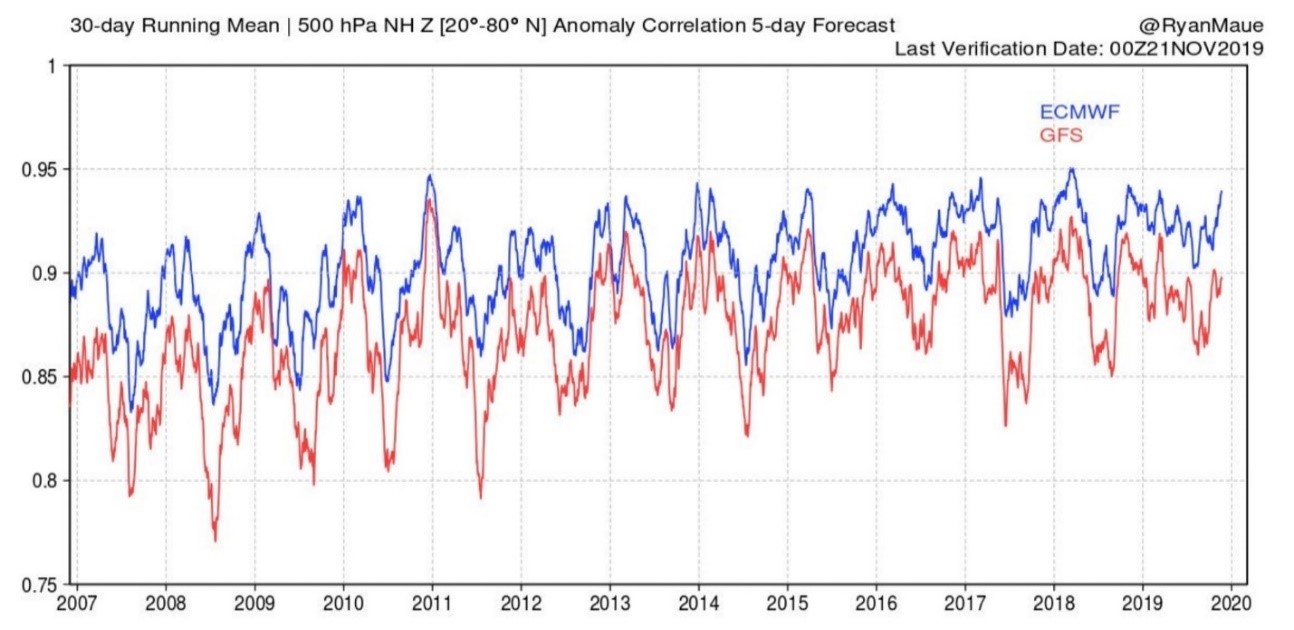
ECMWF vs. GFS Accuracy, 2007-2020. Graphic courtesy of blog.weather.us and meteorologist Ryan Maue.
Weather modeling is a constant work in progress - a journey, not a destination. In 2021, NOAA announced updates to their flagship GFS model with the hopes that over time, the accuracy gap may finally shrink. Updates included the model's resolution increasing from 64 to 127 vertical levels, as well as improved physics and a global wave model, “WaveWatchIII”. New data assimilation capabilities from satellites and aircraft should significantly improve GFSv16 model performance over time. “This substantial upgrade to the GFS, along with ongoing upgrades to our supercomputing capacity, demonstrates our commitment to advancing weather forecasting to fulfill our mission of protecting life and property,” said Louis W. Uccellini, Ph.D., former director, NOAA’s National Weather Service, in a concurrent press release.
But can you prove this updated iteration of GFS is, in fact, comparable or superior to ECMWF? Early results from NOAA’s Model Evaluation Group (MEG) are encouraging, with Xweather Meteorologist Justin Deal sharing the following sentiments:
“They have shown significantly improved frontal boundary and tropical system placements in the medium range. They have shown case after case of v16 pinning down the correct positioning as significantly as multiple days before v15. Extending our tropical system detection lead times is going to be a big help in closing the gap with ECMWF.”
Xweather offers the latest GFS model — among numerous others, both regional and global — for companies to access via an Xweather Flex subscription.
Source: WSI and Praedictix.
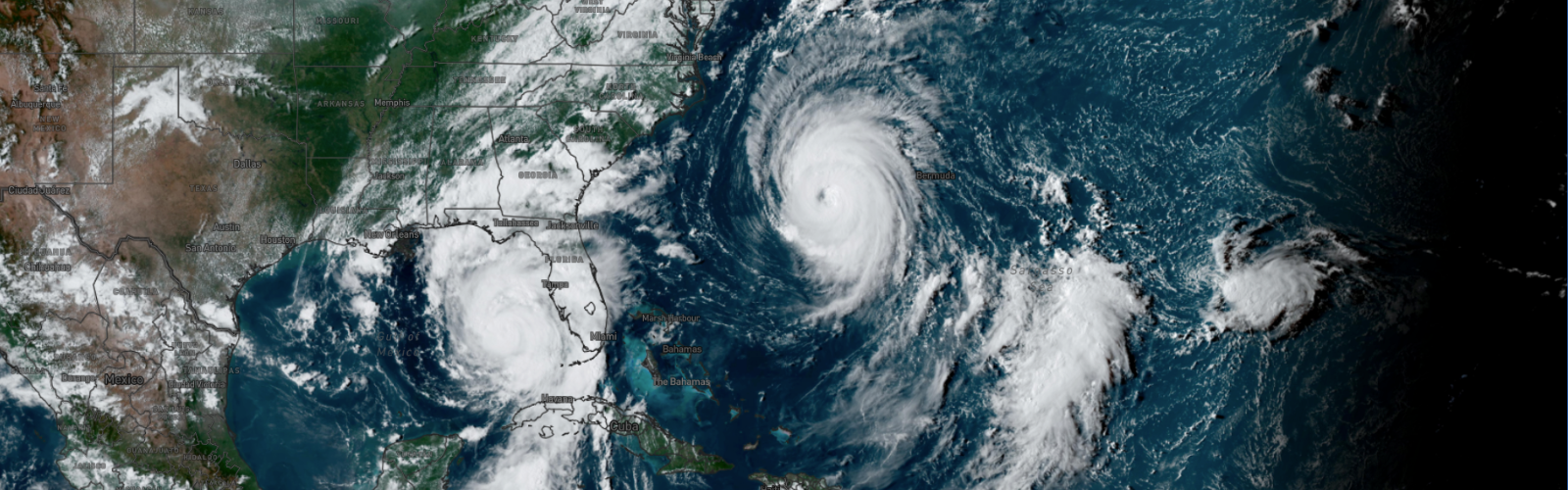
An inflection point for hurricane forecasts?
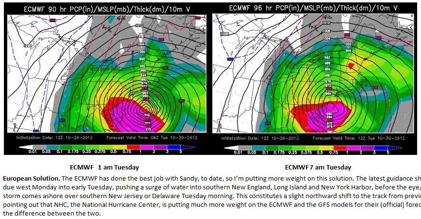
In late October of 2012, ECMWF was the first to predict that Hurricane Sandy would not sail out to sea but instead hook inland toward the New Jersey coast. For many meteorologists, this was one (of many) clarifying moments in deciding which model to rely on most heavily.
It is these “black swan” events that worry meteorologists most: Tropical systems intensifying rapidly before landfall, tornadoes spinning up in areas not under a tornado watch or warning, flash floods striking with little warning. Continued improvements in the GFS model should help to better initialize hurricane models, including HMON and HWRF, resulting in higher-confidence predictions for hurricane path and intensity.
Are the latest improvements enough to make NOAA’s GFS model truly competitive with ECMWF? Time will tell as meteorologists continue generating side-by-side comparisons of the models. One event - one storm - does not tell the tale, but over time we should have an answer to that perpetually vexing question. “I think we're going to see that the time and money spent by NOAA improving GFS (and the FV3 dynamic core) will once again have paid off and provide wide-reaching benefits to the weather industry”, Deal added.
We share Justin's enthusiasm, and we look forward to the results: As meteorologists continue to compare the latest versions of the GFS and ECMWF models over time, we'll find the most accurate and reliable option to put our faith in.
)
)
)